An easy hike up to one of Santa Monica mountains highest peaks, known only to locals and regulars
| Top of Malibu via Schueren Road/Backbone Trail An easy hike up to one of Santa Monica mountains highest peaks, known only to locals and regulars |
| Noticed this giant rock
protruding above a forest ridgeline when I was riding my motorcycle
in the Malibu mountains and always wanted to check it out. So one day,
I drove up with my hiking boots, did some exploring and found the trail
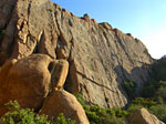
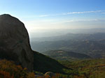
to get to it. The immense rock is impressive, but the entire mountain top is a hikers delight, with erosion-sculpted sandstone boulders, caves and grottos that make a natural sculpture garden you can climb on and explore. The trail went up higher than I expected, to the second highest point in S. Malibu., with a sweeping view from the ocean to the valleys and mountains east. On the west side of the peak is a large FAA antennae station with an access road but there is plenty of natural beauty to distract you on the east side. |
Chances are you'll have this place all to yourself. The Stunt/Schueren overlook where the trail starts is popular with tourists, bikers, lovers and people who walk out the gated fire road southeast to a nice vista. (Also worth a look) But few know about this trail and this mountain with its 300 degree wraparound views of LA county. |
| This peak is about a 1 1/2 -2 mi. climb from the popular lookout park where Stunt Rd. dead ends into Schueren Rd. A sign near the water tank indicates the path is part of Backbone trail, which runs throughout the Santa Monica mtns. I'm unsure if it's a contiguous trail through public lands or segmented by private holdings. You can park in the paved lookout lot or north down Schueren Rd. a few hundred yards in a gravel lot. | Standing at the north end of the paved lot, looking north, you'll see the narrow steep path going up into the chaparral between Schueren Rd. on the left and Stunt Rd. on the right. The path entrance is a scramble and may be overgrown but gets better after it winds around the south side of the giant water tank and up to the top of the mountain. |
| From Hwy. 101 in the San Fernando Valley, exit Topanga Canyon Blvd. west. Go about 2 miles and T/R at Mulholland. T/L at the first light. At the light north of Calabasas High School, this road becomes Mulholland Hwy. Continue about 5-6 miles, T/L on Stunt Rd. Follow Stunt to the top of the mountain until it dead ends into Schueren Rd. and park. | From Pacific Coast Hwy., take Los Flores Canyon Rd, across from Dukes Restaurant, about 8 miles north of Sunset Blvd., to the top of the mountain. When it dead ends, T/R onto Rambla Pacifica. After 1/2 mile, T/R Schueren and follow to the top of the mountain and Stunt Rd. Parking is free. Leave nothing that looks valuable visable in your vehicle. | |
| The Trail | |||||
 Nice view of the vertical rocks on Calabasas Peak and the trail up from Stunt Road. Climbed that in May. |
 Unique rock formations galore |
 Silhouetted hikers. |
 Head shaped rock. |
 The eye |
 The big rock - big version. This rock is so huge, I couldn't find anyplace where I could get it all in the picture. It's as tall as a 4 or 5 story building. Maybe from the air? |
 Northeast to Calabasas |
 Northeast to Calabasas. Calabasas Peak in distance. |
East to W. San Fernando valley | |||
 Looking back to where I took the previous vertical pic |
 Looking up. |
 This mountain has tons of interesting rocks to climb on |
 Did I mention the giant FAA station at the summit? I tried to shield you from it, but oh well..it's there. |
 Looking northwest to the highest peak in S. Malibu (at left) above Latigo Canyon Road. |
|
 Northeast towards Agoura Hills. |
Top of Malibu panorama - small version. This is about a 270 degree view. |
 Top of Malibu panorama - big version. Tall buildings distant left are Warner Center to Santa Monica and the Bay in center, then on around to central Malibu. |
 Fog rolls in over Santa Monica bay up to Palisades Highlands. |
||
Since
Jan.09
|